GPS Accuracy: How Accurate Is Accurate?

Kurt LawtonAg Leader, Education, Equipment, GPS, Guidance, Insights Weekly, Satellite, Trimble

Insights WeeklyIf you’re familiar with yield mapping, automatic boom section control or other tasks that require a GPS signal, you may not truly understand how it works…or you may not care as long as it works, right!

Let me simplify things. Basically, 11,000 miles from earth is a constellation of satellites (between 24 and 32 at any given time) strategically placed and managed by the Air Force. You know this constellation of satellites as GPS. The receiver on your vehicle receives signals from three or more satellites to determine vehicle location. This concept is called “trilateration”; four or more satellites are needed for accurate time and location.

Since GPS satellite signal has to travel through the ionosphere (charged particles in the atmosphere) and space weather (commonly referred to as sun spots), some time error or delay occurs. To correct this and improve accuracy (called differential correction, or DGPS), two receivers are needed to receive the signals. A stationary receiver calculates all signals, measures the timing errors, and then provides a corrected signal to the receiver in your vehicle.

Differential GPS Signals:

WAASWide Area Augmentation System (WAAS)  is an air navigation aid developed by the FAA to add accuracy to GPS by using a network of ground-based reference stations. It is a free signal, and it provides position accuracy within 25 feet or better (sometimes within 7 feet), at least 95% of the time.

OmniSTAR HP service offers a 2-4 inch pass-to-pass accuracy and 4-inch long-term repeatability. It is particularly useful for agricultural machine guidance and many surveying tasks. It operates in real time, and without the need for local base stations or telemetry links. OmniSTAR HP is a true advance in the use of GPS for on-the-go precise positioning.

OmniSTAR XP service offers a 3-5 inch pass-to-pass accuracy and 8-inch long-term repeatability. It is especially suited for agricultural automatic steering systems. While it is slightly less accurate than HP, it is available worldwide and its accuracy is a significant improvement over regional differential systems such as WAAS.

OmniSTAR VBS (not used much in the U.S.) is a sub-meter (less than 39 inches) level of service. A typical 24-hour sample of VBS will be significantly less than 1 meter horizontal position error (95% of the time), with a horizontal error close to 1 meter 99% of the time.

RTKReal Time Kinematic (RTK) GPS  is the gold standard in signal accuracy, placing your vehicle within 1 inch of its target. And RTK system delivers such accuracy by counting the number of wavelengths of the carrier frequency radio signals between a minimum of five satellites and receiver. These systems typically cost more because they require a base station, or tapping into a neighbor or a nearby retailer’s RTK network.

How do you judge what type of signal will best fit your operation.

Pass-to-Pass Accuracy. This measures the relative accuracy of a GPS receiver over a 15 minute interval. This is typically thought of as “guess row error” when driving rows, or skip/overlap from one pass to the next when driving swaths. GPS receivers can provide pass-to-pass accuracy that is acceptable for operations such as tillage, spreading, spraying and harvesting. Typically a DGPS receiver will provide 6–12 inch pass-to-pass accuracy performance over a 15-minute interval.

Year-to-Year Accuracy. GPS receivers using dual frequency technology can be as accurate as +/- 1 inch and can be applied to operations requiring extremely precise fieldwork such as the laying of drip tape directly in preformed beds, or strip-till applications of fertilizer followed by planting of seed directly over such strips of fertilizer. Only GPS receivers using RTK technology can deliver +/- 1-inch year-to-year accuracy. You may have also heard this referred to as “repeatability”, returning to the same location after a time period has passed.

Hope this gives you a brief glimpse behind some of the technology. And don’t forget to check out Ag Leader’s website early next week for a new look, and possibly some other news…

USDA Enlists Added Satellite Remote Sensing Images

Kurt LawtonAerial Imagery, Company Announcement, Remote sensing, Resources, Satellite

USDA crop analysts add another tool to their crop monitoring capability by approving DMCii as a remote sensing solutions provider.

DMCii was invited to supply satellite imagery to the Office of Global Analysis, USDA, Foreign Agricultural Service (OGA USDA FAS) because it provides a unique combination of technical advantages for agricultural monitoring. Firstly, its satellites provide 22m and 32m Ground Sample Distance (GSD) multi-spectral imagery with a large 650km swath width that is capable of monitoring large areas rapidly. Secondly, the company is able to acquire daily images of a given location by coordinating the multi-satellite DMC constellation. Finally, multispectral image data is ideal for monitoring crop growth and is delivered in a highly calibrated Landsat-compatible format for immediate use in crop monitoring applications. DMC data has long been in regular use by precision agriculture services in Europe, where the speed of acquisition, accuracy and very large image size are exactly what is needed for successful monitoring of critical crop growth stages across entire countries.

Bob Tetrault, USDA Satellite Imagery Archive Manager, commented, “The use of DMC satellite data allows the crop analysts to receive broad area, multi-temporal monitoring coverage which is critical in our operational global food security analysis.”

Dave Hodgson, Managing Director DMCii, added, “Our multi-satellite imaging service is ideal for frequent coverage and crop monitoring as the data is collected as large images and delivered in a highly calibrated Landsat-compatible format so applications don’t need to be reinvented.”

DMCii delivers highly calibrated ortho-rectified imagery that can be imported directly into GIS applications. It has delivered 32metre GSD multispectral imagery since the first DMC satellite launched in 2002. The recent launch of two new 22metre GSD satellites, UK-DMC2 and Deimos-1 has greatly increased the imaging capacity of the constellation and has also doubled the number of image pixels per hectare to boost the effectiveness of the system for monitoring agriculture.

By coordinating the constellation of satellites, DMCii covers vast areas within a very short space of time so that data shows the state of vegetation for a very specific period. For example, DMCii coordinated the imaging of 38 countries in Europe within tight time windows specified by each country. DMCii will provide a rapid delivery of data to OGA USDA FAS so that it can be used for rapid decision making during growth seasons.

Cross compatibility is another important consideration when using different satellite imagery. The multi-spectral imagers used on the DMC satellites provide exactly the same spectral bands as the Landsat bands 2, 3 and 4 (R, G, NIR). They are also specially designed to provide highly calibrated imagery, with negligible differences in radiometry between DMC satellites so that data can be combined seamlessly. The large size of DMC images saves considerable time and expense for end users, because they cover huge areas and reduce the need to process large numbers of datasets.

Raven Buys Cellular RTK Precision Farming Technology

Kurt LawtonCompany Announcement, Equipment, GPS, Guidance, Satellite

Raven just purchased a Canadian company that uses cell tower networks to deliver RTK signals.

Ranchview, a start-up company, develops products that use cellular networks instead of the traditional radio systems that are typically used to deliver RTK (Real Time Kinematic) corrections to GPS enabled equipment. RTK corrections improve the accuracy of GPS equipment. The network can also be used to provide high speed Internet access.

“This product line is a natural extension and fits well with our strategy to improve the movement and use of data in agriculture, plus it provides a simpler solution for providing RTK corrections,” noted Raven President and Chief Executive Officer Ronald M. Moquist. “We anticipate that this acquisition will contribute to next year’s earnings. How much will depend on the success of the Ranchview products and services as they are rolled out,” he added.

Matt Burkhart, General Manager of Raven’s Applied Technology Division, explained, “We are aggressively pursuing ways to put the most comprehensive precision ag technologies in the hands of our customers. In the end, growers will benefit from the integration of these products into our lineup and the lower costs necessary to achieve RTK accuracy.”

Can Precision Farming Cure World Hunger?

Kurt LawtonEducation, Farmers, International, Research, seed, sustainability

I hope, as a precision farmer, you’ve added a ‘communicate with consumers’ recurring task to your weekly if not daily chore list. Whether you do it locally or globally, through talking or through social media, you should join the conversation to support your cause.

Part of that effort is to monitor what’s said about your noble profession. To that end, check out this NY Times op-ed piece “Can Biotech Food Cure World Hunger?” It features a variety of opinions–from economists and activists to nutritionists, university and thinktank folks.

There’s good give and take in these messages, and excellent food for thought. And, if you want to have Google help you track down such stories and send them to your email, it’s real easy to do. Sign up for a Google email account (Gmail) if you don’t have one, then visit Google Alerts and type in numerous words (such as agriculture, farming, farms, GMO, livestock, food, biotech, corn, soybeans, wheat, cotton, USDA, etc.) that Google will find in stories, then email those story links to you.

Canadian Precision Farming Entrepreneurs

Kurt LawtonAerial Imagery, Dealers, Fertilizer, International, Remote sensing, Retailers

Farmers Edge Precision Consulting based in Winnipeg, Manitoba has become a fast-growing business helping farmers cut fertilizer costs and increase profits. The two agronomy experts who started the company just received an entrepreneur award, according to a report in The Gov Monitor.

Farmers were so impressed with an innovative crop fertilization service developed by Curtis MacKinnon and Wade Barnes that they urged them to take it to market, giving them the push they needed to strike out on their own. Since that initial start four years ago, Farmers Edge Precision Consulting has become a fast-growing business that is helping farmers across the Prairies and as far away as Russia improve their practices and profits. For this success, Wade, 34, and Curtis, 33, have won BDC’s Young Entrepreneur Award for Manitoba.

Farmers Edge helps take the guesswork out of farming. It combines remote sensing equipment and technology to redefine how farmers apply fertilizer to their fields to increase crop yields. The business is helping grain and oilseed farmers increase their profits by $15 to $100 per acre, while contributing to a 15 to 25% decrease in fertilizer application. Now covering 750,000 acres across the Prairies, Farmers Edge has grown to 10 management partners, 34 full-time and 11 seasonal employees, along with 17 consulting partners who are re-sellers of the services. Farmers Edge has just opened its own soil-testing laboratory, has taken its concept to large corporate farms in Russia and is constantly exploring new ideas.

“Before we got started, I was working in the fertilizer business, where research had been done on variable rate technology, but no one had found a way to make it viable,” explains Wade. “Then I started working with Curtis, who is gifted in technology, and together we decided to reinvent the wheel.” Wade hit on the idea of using remote sensing to map out the varying fertilizer needs throughout a field, and Curtis found a way to make fertilizer machines vary their output according to that map. When farmers saw what Farmers Edge could do, the service sold itself.

The two agronomy experts attribute the fast growth of Farmers Edge to the talented team and the unique ownership model they have put in place. That includes a design whereby territory managers take equity in the company. “We have been fortunate to find key people who share our drive,” says Curtis. “That has allowed us to keep growing and expanding.”

Curtis and Wade see expansion as a way of reducing risk. “Agriculture is so influenced by weather that if you are regionalized, one weather disaster could virtually wipe you out,” explains Wade. “Expanding into other regions reduces that risk.” They’re also always on the lookout for possible new ventures. “We’re very quick to seize opportunities. If we have an idea, we chase it.” That led them to Russia in 2006. Since then, Farmers Edge has been developing business in Russia and the Ukraine, tapping into the large corporate farm market.

Talk Precision Farming With Your Seed Dealer

Kurt LawtonAg Leader, Education, Equipment, Harvesting, Insights Weekly, seed

Insights WeeklyFirst off, I order 12 consecutive days of sunshine across the US so we can keep those yield monitors spinning to map data—to help close out a very odd summer and fall.

Hybrid/Variety Yield Mapping -- Overlay planting maps with real-time harvest maps to view instant yield result variations by hybrid/variety in the field. This provides better seed selection data for next planting season.

Hybrid/Variety Yield Mapping -- Overlay planting maps with real-time harvest maps to view instant yield result variations by hybrid/variety in the field. This provides better seed selection data for next planting season.

Thinking of brighter days ahead, be sure to make mental/written notes as harvest progresses, because hybrid/variety selection time is upon us. To that end, I talked this week with Pioneer sales rep and Ag Leader master service dealer Mike Anderegg, who advises his seed clients on all things seed and technology near Clear Lake, Iowa.

Mike helps growers understand the value of farm data, and how it can truly help hybrid and variety selection—one of the most important decisions you make each year. “Data collection is an evolution which usually starts with visual yield monitoring (just watching it, not recording), then using GPS to map it. Once growers start to analyze maps and think about the impact of their management practices—that’s when the desire for more data usually begins,” Anderegg says.

“Yields alone can perhaps tell them that they waited too long to harvest these soybeans, or perhaps they needed to harvest corn at a different moisture level,” he says. Growers quickly see the value in adding data layers for soil type, soil fertility levels, hybrid/variety maps and more.

“The data is all about seeing trends along hybrid and varietal lines. When you know the ground and your agronomic practices, we can look at hybrids on slow cool early soils, on lighter droughty soils, on middle ground, on corn-on-corn and first-year corn. And this data then helps deliver better future recommendations,” Anderegg adds.

“Along with seed advice, I can offer growers precision farming technology that can do anything and everything they want. The challenge is making it work with best agronomic practices, and having an adoption plan to make it all work together. I help growers think through what practices they want to do—from yield gathering and mapping to variable-rate planting, fertilizing and spraying. We also talk about whether moving tools between vehicles is desired. Then we can craft a technology adoption plan that fits their agronomic desires. And one that helps them make more money,” he says.

Planting With Precision For Southeast Farmers

Chuck ZimmermanAudio, Sunbelt Ag Expo

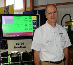
Bruce SauderBesides taking part in the field demonstrations at Sunbelt Ag Expo I also wandered through the indoor exhibits. The first one I stopped at was Precision Planting. I spoke with Bruce Sauder about what is new with the company that producers were getting to see in their exhibit.
He says that some of the new units that they’ve come out with this year include a 20/20 RowFlow Module that controls the population rate of seed as you move through the field and swath control for minimizing overplanting. Bruce says the swath control can save as much as 2 bushels of seed in a 240 acre center pivot.

You can listen to my interview with Bruce below:

Sunbelt Ag Expo 2009 Photo Album

Precision In The Field at Sunbelt Ag Expo

Chuck ZimmermanSunbelt Ag Expo, Trimble, Video

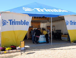
Trimble BoothThe 2009 Sunbelt Ag Expo has concluded and it did include a number of exhibits from precision product companies. One of those, having the largest field demonstration wasTrimble. I stopped and spoke with Matt Hesse, Autopilot Sales Manager.

The company was showing various levels of precision integration. They had two different land leveling systems. One used a GPS control and one used a 2D laser system. They also had their new TrueGuide passive implement steering system in use. This system puts an antenna on the implement to tell the tractor where it is so the tractor knows how much to move in relation to the desired line to optimize the placement of the implement. They also had their TrueTracker System on multiple tractors and implements.

Matt says that they take applications that are not possible for human beings and put them into a machine to do it for us. This ultimately increases efficiencies that have produced up to 20 bushels per acre increases in corn.

Feel free to check out my photos from this year’s Sunbelt Ag Expo 2009 Photo Album. My visit to the show was made possible by Growth Energy.

Hi-Tech Wired Magazine Talks Precision Farming

Kurt LawtonEquipment, Farmers, Fertilizer, GPS, Guidance, Precision Ag in the News, Satellite, Spraying, sustainability

Always good to see high technology magazines talk about precision agriculture that’s happening down on the farm. My favorite hi-tech pub, Wired, just posted a nice story on their website: “Self-Steered Tractors and UAVs: Future Farming Is (Finally) Now.” A lot of the story was based on Idaho grower Robert Blair, who was named PrecisionAg’s 2009 Precision Farmer of the Year.

It talks about the rapid adoption of auto steer due to payback, the big generational shift going on, unmanned aerial vehicles (UAVs) to survey crops, yield monitors and maps, variable-rate applications and much more.

It also mentions environmental challenges and talks some about sustainability, handling those topics in a fair manner.

Read it, and pass it along to your town and city friends. The more educating we do with the general public, the better!

A Precision Gator

Kurt LawtonEquipment, John Deere

John Deere has now updated its popular autonomous R-Gator utility vehicle with a refined chassis, based from the M-Gator military platform vehicle.

The go-anywhere R-Gator now features independent suspension and improved ground clearance. And it also boasts a faster top speed, travelling up to 35 mph in manual mode.

“Since we’re always looking to improve our products, we’ve been running R-Gator exercises with soldiers and marines,” said Mark Bodwell, worldwide military affairs group manager for John Deere. “Through those exercises, we’ve come to appreciate just how important it is to be able to navigate hilly or rough terrain quickly. The improved R-Gator was developed in direct response to the military feedback we received.”
The R-Gator has 11 inches of ground clearance and its four-wheel, independent suspension is fully adjustable for improved mobility and superior fording capabilities.

Based on the proven M-Gator military vehicle platform, the R-Gator employs commercial off-the-shelf technology and includes precision guidance, navigation and obstacle avoidance technology that has been at work for two decades in John Deere’s agricultural products. The R-Gator can be operated in manual, tele-operational or fully autonomous mode during day and night and supports military personnel through lightening the load, persistent stare, cargo carrying, point-man reconnaissance, roving patrols, resupply, casualty evacuation and more.

“John Deere has a long history of supporting the U.S. military,” said Bodwell. “We’re proud to do so and we’re committed to providing the products and features our servicemen and women need and request. The R-Gator is just one more example of that commitment.”