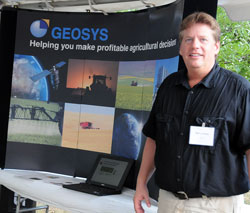
 Precision ag was highlighted at the Nutrient Use Efficiency Expo during the recent Conservation in Action Tour by a company called Geosys. Company representative Don Lampker says they do a lot with satellite imagery and have a product called FieldInSite which helps farmers map their fields so they can make decisions on which areas are most productive. They can then create nutrient management plans for variable rate application systems.
It’s all about the more efficient use of nitrogen so Don says there may be some areas of a field where they actually apply more nitrogen while in other areas it will be reduced if it’s not getting used efficiently.
Listen to an interview with Don from the CTIC tour here: [wpaudio url=”http://zimmcomm.biz/ctic/ctic-10-lampker.mp3″ text=”Don Lampker Interview”]
Conservation In Action Tour 2010 Photo Album
Coverage of the Conservation In Action Tour was made possible by ![]() and the
and the ![]()
