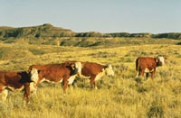
 Here’s another use for aerial imagery – helping ranchers decide how many cows they can support per acre, as well as how much carbon rangeland plants store.
A study by the Agricultural Research Service (ARS) and the University of North Dakota lays a foundation for eventually allowing ranchers to get Web-based information on the quality and quantity of forage plants in their fields. Ranchers could use this information to determine stocking rates, as well as how much carbon is stored in their forage plants.
Scientists Rebecca Phillips and Ofer Beeri have developed a way to measure rangeland forage plant yields in pounds per acre, and their quality in percent of protein content, over many acres. They’re using commercial HyMap hyperspectral imagery taken by airplane, which lets them capture images at more than 200 wavelengths—all of the light in the visible wavelength bands and invisible near-infrared and short-wave infrared wavelength bands.